
-

Drifter Data Buoy
Drifter is Frankstar’s intelligent wave observation buoy, equipped with high-precision sensors for waves, temperature, and pressure monitoring, and designed for both drifting and moored deployment. It provides real-time, accurate measurements of wave height, direction, period, sea surface temperature, and sea level pressure . Data is transmitted via Iridium satellite to the cloud for instant access and is also stored locally for retrieval after recovery. Compact, robust, and easy to deploy, the Drifter delivers professional, high-quality ocean data to support marine monitoring,
-
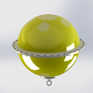
Mini Wave Buoy GRP(Glassfiber Reinforced Plastic) Material Fixable Small Size Long Observation Period Real-time Communication to Monitor Wave Period Height Direction
The mini wave buoy is a compact, high-precision oceanographic buoy engineered by Frankstar for high-mobility marine monitoring. Built to deliver reliable, long-term observation of wave dynamics, sea surface physical elements, and environmental parameters, it seamlessly adapts to both free-drifting ocean profiling and fixed-station mooring deployments. Equipped with low-power multi-channel sensor integration, the system continuously captures high-fidelity ocean data and transmits real-time telemetry back to land stations or cloud platforms via satellite, cellular, or radio networks.
-
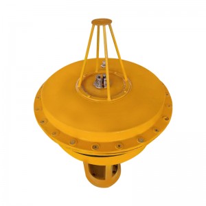
High Accuracy GPS Real-time communication ARM processor Wind buoy
Wind buoy is a small measuring system, which can observe the wind speed, wind direction, temperature and pressure with the current or in fixed point. The inner floating ball contains the components of the whole buoy, including weather station instruments, communication systems, power supply units, GPS positioning systems, and data acquisition systems.The collected data will be sent back to the data server through the communication system, and customers can observe the data at any time.
-

S12 Multi Parameter Integrated Observation Data Buoy
The S12 Multi-Parameter Integrated Observation Data Buoy (Model: FS-MDB-S12) is an intelligent, high-performance ocean observation buoy platform engineered by Frankstar. It enables all-weather, continuous, real-time in-situ monitoring across meteorology, hydrology, water quality, ecology, and other marine parameters.
Featuring excellent industrial design and high payload compatibility, the buoy platform accommodates flexible sensor configurations. The top platform houses meteorological, communication, positioning, and navigation safety equipment, while the structural body and lower frame allow the integration of advanced hydrological and water quality sensors. Collected data can be transmitted to the Frankstar MEINS (Marine Equipment Intelligent Networking System) platform or user-specific management platforms in real time via Satellite, GSM/GPRS/4G, UHF/VHF, and other communication options, enabling remote access, visualization, and cloud storage.
-

S16 Multi Parameter Integrated Observation Data Buoy
The S16 Multi-Parameter Integrated Observation Data Buoy (Model: FS-MDB-S16) is an intelligent ocean observation buoy platform engineered by Frankstar. It provides all-weather, continuous, and real-time in-situ monitoring across meteorology, hydrology, water quality, ecology, and other marine parameters.
Featuring an optimized structural design and high payload compatibility, the buoy platform supports flexible sensor configurations. The top platform accommodates meteorological, communication, positioning, and navigation safety equipment, while the main hull body and lower bracket allow integration of advanced hydrological and water quality sensors. Collected data can be transmitted to the Frankstar MEINS (Marine Equipment Intelligent Networking System) platform or the user’s own system in real time via Satellite, GSM/GPRS/4G, UHF/VHF, and other communication options, enabling convenient remote access, visualization, and cloud saving.
-

S30 Multi Parameter Integrated Observation Data Buoy
The S30 Multi-Parameter Integrated Observation Data Buoy (Model: FS-MDB-S30) is a large-scale, intelligent ocean observation buoy platform engineered by Frankstar. It is designed for all-weather, continuous, and real-time in-situ monitoring across meteorology, hydrology, water quality, marine ecology, and other marine environmental parameters.
With high payload compatibility and an advanced industrial design, the buoy platform supports flexible, multi-sensor configurations. The upper tower platform accommodates meteorological, communication, positioning, and navigation safety equipment, while dedicated dual instrument wells allow seamless integration of deep hydrological, water quality, and ecological sensors. Collected data can be transmitted to the Frankstar MEINS (Marine Equipment Intelligent Networking System) platform or user-specific management platforms in real time via Satellite, GSM/GPRS/4G, UHF/VHF, and HF communication options, providing reliable remote access, visualization, and cloud data saving.
-

Radar Water Level & Velocity Station/non-contact radar velocity sensor, radar level and flow velocity station, IoT radar water level velocity measurement, solar powered radar water level velocity station
Frankstar Radar Level Velocity Station adopts non-contact radar measurement technology to achieve high-precision, all-weather and automatic water level data collection for rivers, channels and other water bodies. It effectively overcomes the drawbacks of traditional contact sensors, such as siltation, icing, floating debris impact and biological fouling, ensuring long-term reliable data.
Integrated with a positioning system, 4G/5G communication and a high-efficiency solar power supply system, the Station enables long-term unattended operation in remote field environments without mains power or network coverage, greatly reducing operation and maintenance costs. Collected data is transmitted in real time to the monitoring center or cloud platform, providing a scientific basis for flood control, disaster mitigation, water resource management and ecological protection, while significantly improving emergency response efficiency and the safety of water conservancy facilities.
-

Automatic Tide Guage Station/Automatic Tide Gauge Station, radar automatic tide gauge, solar powered automatic tide station, IoT tide level sensor, real-time automatic tide gauge
Frankstar automatic tide gauge station is an automatic telemetry tide and water level monitoring system developed by Frankstar for continuous, real-time observation of water level and water temperature in coastal and inland environments.
Designed for long-term unattended operation, the system provides reliable hydrological data for environmental monitoring, water resource management, and marine applications.
-

In-situ On-line Five Nutrient Monitoring Nutritive Salt Analyzer
Frankstar Nutritive Salt Analyzer is an in-house core R&D achievement. The instrument fully simulates laboratory manual analytical procedures and realizes high-quality in-situ online monitoring of five nutritive salt parameters within a single device, including nitrite nitrogen (NO₂-N), nitrate nitrogen (NO₃-N), phosphate (PO₄-P), ammonia nitrogen (NH₄-N) and silicate (SiO₃-Si). Equipped with a matched handheld terminal, it simplifies parameter configuration and delivers user-friendly operation. The analyzer supports flexible deployment on ocean buoys, survey vessels and other marine monitoring platforms.
-

Self Record Pressure and Temperature Observation Tide Logger
FS-CWYY-CW1 Tide Logger is designed and produced by Frankstar. It is small in size, light in weight, flexible in use, can obtain tide level values within a long observation period, and temperature values at the same time. The product is very suitable for pressure and temperature observation in nearshore or shallow water, can be deployed for a long time. The data output is in TXT format.
-

UHMWPE High-Performance Rope/HMPE synthetic winch rope, ultra high molecular weight polyethylene rope, Dyneema high strength rope
Engineered from premium Ultra-High-Molecular-Weight Polyethylene (UHMW-PE) fibers and refined through an advanced rope-body enhancement process, Frankstar UHMW-PE Rope features a proprietary surface-lubricant coating that markedly increases smoothness and abrasion resistance. The special treatment taken by Frankstar locks color fastness and preserves long-term flexibility, ensuring the rope remains supple even after extended service.
-

Aramid Fiber Rope/Aramid fiber rope, high strength aramid rope, heat resistant aramid fiber rope, Kevlar aramid fiber rope, braided aramid fiber rope
Engineered for the marine environment, this line combines an aramid-fiber core with a polyamide-fiber outer construction. A low-helix-angle braid and pre-stabilized construction minimize break elongation, ensuring stable station-keeping. The high-density surface weave maximizes abrasion resistance, while a dual-color identification system simplifies sub-sea installation. Multi-layer reinforcement withstands extreme sea-state impacts, making the line ideal for high-load applications such as subsurface buoy and mooring-anchor systems.





